A few selected maps and one report, all relating in some way to the Pitt River Watershed.
Landscape units
Widgeon (PDF); Pitt (PDF); Alouette (PDF); Stave Lake area (PDF)
Legal Descriptions
Pitt to Harrison Lake (PDF); Harrison Lake to the Fraser River (PDF)
Historic Licensee operating areas ( Chilliwack Forestry District ) (PDF)
Lower Fraser Sustainable Resource Management Plan, SRMP (54 pages) 2013 (PDF)
Radio Channels being used up to 26 November 2015 (PDF)
Old Growth Managment in the Chilliwack Forestry District (PDF)
Squamish Foresty District
Squamish Operating tenures (PDF)
Old Growth Squamish Forestry District (PDF)
Squamish Forestry District Bridge Locations (PDF)
And a few images in a not so common format, from the Lands Office. Both are of the Upper Pitt River, and show some of the premptions. You will need to have one of the appropriate converters installed since they are both in MrSID format ( Download Screen ) PNWS02Tr07 and PNWS27Tr01
NOTE: If any of these links do not work, please email me, and I will host the documents elsewhere.
The links are all to the FTP sites of the Chilliwack and Squamish Forestry Districts
Monday, January 4, 2016
Saturday, March 14, 2015
Convicted guide operates in the Upper Pitt
From the Vancouver Sun: Convicted guide outfitter allowed to continue operating in B.C.
Abe Dougan has 20-year ban from hunting and guiding in Yukon.
A sane person would hope that the conviction and sentencing in this case, would also automatically trigger censure in Canada, apparently Not.
Forty-three is a considerable amount of black bears to lose from this area ( mis-management unit ) and this is just ONE guide. No mention of the other guides, and just regular hunters and what they removed.
Saturday, January 17, 2015
Short videos
I came across a few short videos, the longest being about 15 minutes in length, all created by Nick Didlick Photography
The fishing bears of the Pitt river
Grizzly Bears in the Pitt River Valley
Fishing with Sven
Where the Wild Fish Live
Pitt River Aerial Tour this is the longest video, it takes you by helicopter from the mouth of the Upper Pitt River, all the way along the river to the boundary with Garibaldi Provincial park.
Cheers
Friday, October 12, 2012

Sunday, October 30, 2011
Grant Narrows
From the Georgia Strait; In the Grant Narrows wilds, it's another world
Time will tell how the new ownership goes.
Time will tell how the new ownership goes.
Thursday, November 19, 2009
Wednesday, January 16, 2008
Dealing with the Run of River issue
This blog will be open to all for a discussion about the issues, that effect the Upper Pitt River.
A website has been set up. Upper Pitt River primarily to put into one place all the information about the Upper Pitt River that is available.
Feel free to place your comments at the bottom of this post, or
E-Mail a message.
And also two other blogs Pitt River and one about Pitt Lake which will primarily be filled with the history, ecology and the issues that affect the Watershed.
Subscribe to:
Posts (Atom)
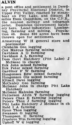
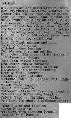
Alvin 1918
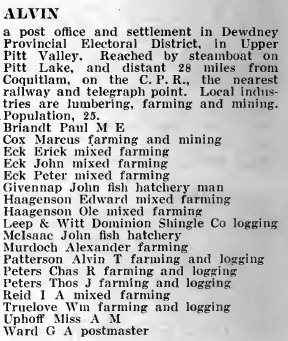
Alvin 1919
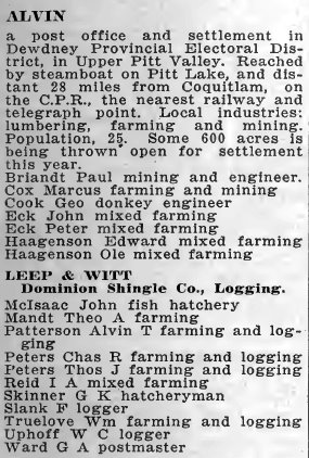
Alvin 1920
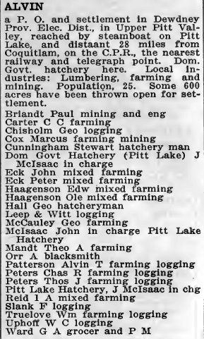
Alvin 1921
Alvin 1922